
Maps & Geocoding
ForeBranch Pro can look up map coordinates for the places in your tree and show them on interactive maps, so visitors can see where your family lived.
Where maps appear (Pro)
- On place pages, when the place has coordinates.
- On the person page’s LifePath tab, in the Life Journey Map.
- On the admin Edit place screen, where you can click the map to set a location.
With Make place names clickable turned on under Configuration → What to Show & Hide, place names also link to Google Maps.
Before you geocode: merge duplicates
The recommended order is merge, then geocode, then review corrections. Merging first avoids looking up the same place twice.
- Go to ForeBranch → Places → Merge.
- Click Find Duplicates to review groups, or Auto-Merge All to merge exact name matches automatically.
See Places (Pro tools) for details.
Geocode your places
Open ForeBranch → Places → Geocoding.
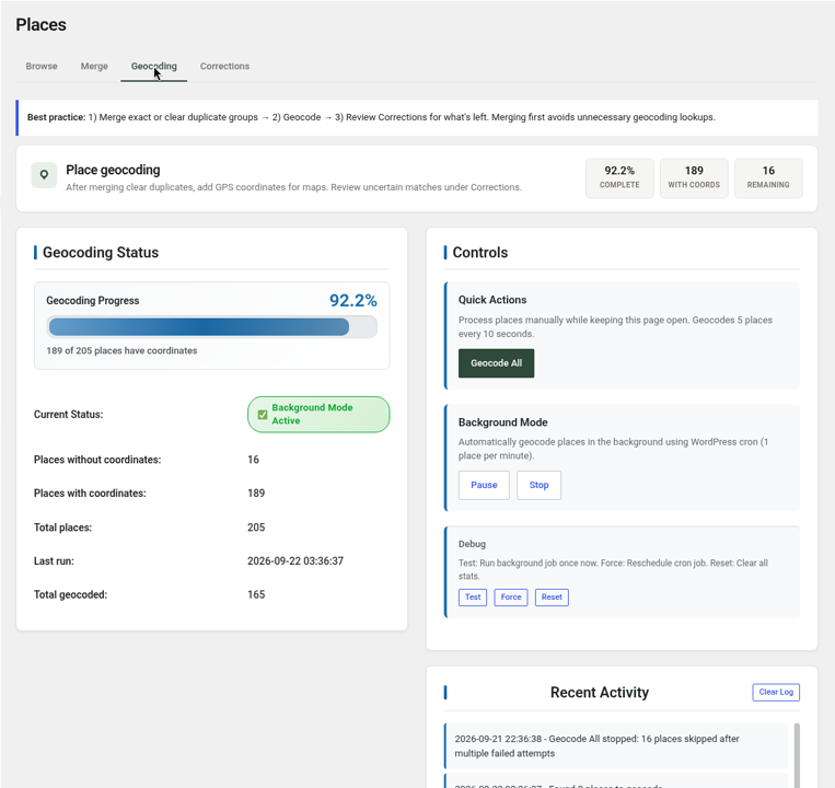
Check your progress
The tiles and Geocoding Status panel show the percentage complete, places with and without coordinates, the total, the current status, when it last ran, and the total geocoded.
Option 1: Geocode All (fast, keep the page open)
- Under Quick Actions, click Geocode All.
- Keep the page open. ForeBranch geocodes 5 places every 10 seconds.
- Watch Recent Activity for progress.
Option 2: Background Mode (slow and steady)
Background Mode geocodes 1 place per minute using WordPress cron, so you do not need to keep the page open.
- Click Pause to pause it, or Stop to stop it.
- Under Debug: Test runs the background job once now, Force reschedules the cron job, and Reset clears all stats.
When places are skipped
Places that fail several times are skipped, and the log says so (for example, “16 places skipped after multiple failed attempts”). For those places:
- Go to ForeBranch → Places → Browse and click the Without Coords tile.
- Click a place ID to edit it.
- Click Get Coordinates, click the right spot on the map, or type the latitude and longitude.
- Click Save place.
To try a place again from scratch, tick it on Browse and use Reset & Re-geocode from Bulk Actions.
Review corrections
When a match is uncertain, the place goes to ForeBranch → Places → Corrections. High-confidence renames are applied automatically and listed in Applied history.
- Open the Review queue.
- Click Accept for a good suggested rename, or Approve coords when only coordinates were found.
- Click Reject coords for a wrong match. The coordinates are cleared so the place can be retried later.
After accepting renames, update the same names in your genealogy software so future imports stay in sync.
Keep your coordinates safe
- Re-import with Update tree. New / replace tree deletes everything in the tree, including place coordinates you added.
- Back up your database before big changes.
About the geocoding service
Geocoding uses Nominatim from OpenStreetMap. ForeBranch sends only the place name or coordinates being looked up, and only when an administrator runs geocoding or clicks Get Coordinates. It is not called on public page views. Maps use OpenStreetMap tiles. See the Nominatim usage policy for details.